- Home
- Language & Culture
- 1A-What is Ngan'gi?
- 1B-Differences between Ngan’gikurunggurr and Ngen’giwumirri
- 1C-How Ngan'gi is related to other languages.
- 2-Ngan'gi Country
- 3-Ngan'gi Sounds & Writing
- 4-Ngan'gi Verbs
- 5-Serialised Posture Verbs
- 6-Bodypart Nouns inside the Complex Verb
- 7-Noun Case
- 8-Noun Classes
- 9-Ngan'gi Family, Societies & Subsections
- 10-Ngan'gi Kin
- 11-Wangga & Lirrga Song Styles
- 12-A Sample Ngen'giwumirri Story
- 13-Ngan'gi Publications
- Texts
- Audio & Video
- Photos
- Dictionary
- About
2 – NGAN’GI COUNTRY

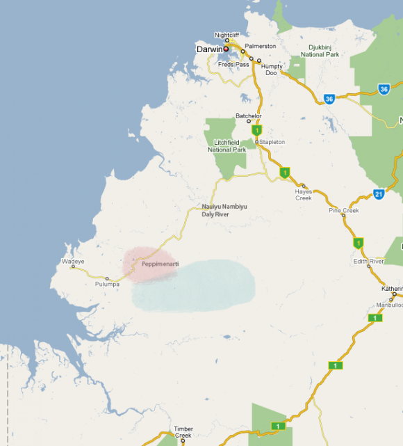
Disclaimer: This image indicates only the general location of Ngan'gikurunggurr and Ngen'giwumirri countries. Boundaries are not intended to be exact. Not intended for native title or land claim purposes.
The land to which the Ngen'giwumirri (the blue blot in the map above) and Ngan'gikurunggurr (the pink blot in the map above) belong is wonderfully diverse. The eastern and northern Ngen'giwumirri estates of rak-Merren and rak-Lafuganying are situated in the Wingate mountains, and are characterised by deep lush gorges between arid sandstone mesas. Running westwards from the Wingates through the Ngen'giwumirri estates of rak-Nudik, rak-Tyingirim, rak-Nganambala, rak-Malfiyin and rak-Papangala, is a sandstone escarpment, up to a hundred metres in height, that splits the country into two distinct geographical zones. The top of the escarpment ninymunggurr, descending gradually southwards towards the Fitzmaurice river, is dry and rocky, mostly spinifex and sparse trees stunted by lack of water. The top of the escarpment is not suitable to sustain permanent habitation, but was frequently used for east-west travel, particularly during the wet season when the low black soil plains were difficult to cross. The lip of the cliff wall is well watered, dotted with permanent springs, each surrounded by small rings of thick vegetation, and the spring water cascades down the cliff in spectacular waterfalls.
In contrast to the top of the escarpment, the low level country holds its water and supports a rich diversity of flora and fauna. Flowing from pockets of rainforest along the base of the escarpment wall, through open forests of Eucalypts interspersed with pandanus and cycads, the Moyle river and its tributaries gently descend westwards into large flood plains of black clay soil before disappearing into the marshland of the vast muyil swamp that stretches from Peppimenarti thirty-five kilometres to the sea.
The seven Ngen'giwumirri estates that are represented by people presently living at Peppimenarti are roughly strung out in an east-west line, each consisting of both high escarpment and low plain country. The boundary of the easternmost state, rak-Lafuganying, runs the whole length of the Fish river, from Kuluy (Collah Spring) northwards to its junction with the Daly river. The northern boundary, between the rak-Merren estate and Gamu/Matngela/Marramaninjsji country, roughly follows the Daly – Peppimenarti road (which in turn follows the old Daly – Port Keats walking track). The southern neighbours, around the Fitzmaurice river, were the Jaminjung, and on the western side the Marringarr. East to west then, Ngen'giwumirri country extends just over one hundred kilometres, from the Fish river to the muyil swamp near Wudipuli.
As can be seen from the map above, Ngan'gikurunggurr country is smaller, bordered on the southern and eastern sides by Ngen'giwumirri. The northern Ngan'gikurunggurr estates of rak-Fepiminati and rak-NgambuNgambu respectively abut Marramaninjsji country and the Marrithiyel-speaking rak-Marri Dan estate group. The four other Ngan'gikurunggurr estate groups to the south-west of these, NintyiNintyi, Merrepen, Nerintyi and Ngulfe, are located lower in the floodplains. Before the establishment of present-day communities, during the worst of the wet season, rak-Nerintyi and rak-Ngulfe people often had to abandon their own estate holdings to the rising floods and camp on the fringes of the rak-Merrepen and rak-Fepiminati estates.


